
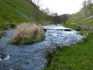
 The first few hundred yards within the dale feel claustrophobic after so long in the wide open spaces, and the canopy of trees overhead and the encroaching undergrowth grabbing at your ankles only exacerbates the feeling. In spring wildflowers carpet the narrow margins - bluebells, ramsons, ground ivy and, between path and river, butterbur and wild rhubarb or gunnera. Mosses thickly coat the loose rocks; little rustling noises hint at the presence of birds or small mammals snuffling for grub; dappled sunlight reflects off the river’s surface; and the gentle splash of water tumbles over the numerous tiny weirs in an unobtrusive soundtrack as you make your way reverently, as though in a cathedral.
The path now sticks close to the river, mirroring its twists and turns, initially on the Derbyshire bank before crossing by way of a small wooden footbridge into Staffordshire. Before this, though, the silhouette of Beresford House appears high on the hillock opposite. Of historical, if not aesthetic, importance to our story, it was here that the friendship between Charles Cotton (the owner) and Izaak Walton flourished in the middle years of the seventeenth century, eventually leading to the publication of The Compleat Angler - more of which anon.
 The path crosses the footbridge just above Pike Pool, where the first of those rock formations appears as an obelisk poking some twenty or twenty five feet vertically out of the water, almost forming an island but instead creating a deep plunge pool where indolent trout lurk for unwary insects. Incidentally, it is the obelisk rather than the carnivorous fish for which the pool is named. Its association with Walton and Cotton has brought it a level of fame within the angling community that is possibly out of proportion to its present condition as a fishery - just upstream is a notice from the current Estate Manager regarding the local water authority’s sanction to release a certain amount of chemical waste into the river with a consequent reduction in insect, bird and fish populations. Famed as one of the country’s foremost trout rivers, the Dove went through a period (in common with practically every other waterway in Britain) when pollutants had a hugely detrimental effect on biodiversity. However since the bleak days of the sixties and seventies major strides have been made to bring the water quality back towards what it once was. This has been such a success that salmon are now hatching once more, although trout are surprisingly showing something of a decline in recent years, maybe as a result of increased numbers of cattle drinking and paddling in the shallows and helping to increase silt levels within the water, which impacts on the eggs ability to hatch. Measures are being put in place to assist with the problem and should hopefully show results within the fairly short-term. Nonetheless the fact that the issue has been identified and plans formulated is a positive sign and shows how environmental concerns have become accepted as being of increasing importance over the course of the last twenty or thirty years. The picture is a more positive one than it was in the days when DDT and other pesticides were spread indiscriminately across the and, but the need for care is a constant one and the request for vigilance on the Estate Manager’s sign is a point well made.
Just beyond Pike Pool a minor road terminates at the very bank of the river, where once was a ford but now is an extremely narrow footbridge. The ford is named on local maps as Beaver’s Ford and it takes little imagination to see how it mutated to Beresford over the years. With the wolf of Wolfscote Dale (and such nearby locations as Wolf Edge above Flash and Wildboarclough below Shining Tor) it is clear that mammals long extinct from Britain once lived here in the English Midlands but remain in name only. It is here that I park on occasional summer evenings and wander downstream, shedding the stresses and strains of the day as I go . Across the bridge is a wide grassy water-meadow, often flooded, at the far side of which a gap in a dry-stone wall is the doorway between Beresford and Wolfscote dales. To the right a ramshackle bridge leads a path away towards Narrowdale and Alstonefield but our way lies dead ahead, unless a brief uphill diversion is desired to Frank i’ the Rocks Cave - a hollow within one of the limestone outcrops that has been given the distinction of a name. It is pure conjecture on my part but I wonder if a hermit named Frank once lived here and has left his name with the rocks for posterity.


 Immediately below the little bridge is one of the many tiny weirs that slow the river’s flow and helped to make it, in the words of Charles Cotton, “the finest trout stream in all of England”. the water backs up prior to flowing over the weir and creates a little pool which seems to invite a number of duck species to gather and make the most of the shade from the surrounding fir trees. Mallards, coots, mergansers, moorhens - all can be seen and enjoyed but the two ornithological highlights of this stretch are not ducks. There are four water birds that I love above all others - dabchick (or little grebe), dipper, kingfisher and heron. We shall hopefully meet the dabchick and kingfisher further along our journey but it is a rare visit to Wolfscote Dale when you don’t see a dipper, and when talking with friends I use the name Herondale to describe where I’ve been, as bird and dale are inextricably linked in my mind. One of the first times I visited was a Friday evening, walking with Sarah after a hard week at work We strolled along in companionable silence when Sarah squeezed my hand slightly tighter and gestured with her eyes that I should both stay quiet and look to my right. I did and was amazed to see just ten or fifteen feet away a heron stood on a rock in the middle of the stream , stock still as it stared into the crystal clear water, waiting for food to swim within reach of its dagger-like beak. We watched for twenty minutes before leaving it to its patient vigil. It was still there when we returned twenty minutes later. I’d seen herons before but that night fell in love with them to the extent that they now rival the kingfisher for my affections.
Wolfscote Dale is a more open valley than Beresford Dale, sunnier, less wooded by and large and as a result more welcoming to herons. Common spotted orchids are a feature in late spring and early summer and add immeasurably to the pleasure of a late evening amble; the attractive blue-violet of meadow cranesbill punctuates the green foliage on either side of the path; wrens flutter in and out of the self-same foliage; sheep respond to the bleating of their lambs. All is well with the world. The stresses and strains that you brought with you have disappeared.
 On the far (Staffordshire) bank dry-stone walls defy gravity, being built directly uphill on a seemingly impossible gradient. How (and why) anybody built them in such straight lines is difficult to comprehend. These days it wouldn’t happen and, as they begin to crumble and fall, I very much doubt that they will be repaired to anything like the same design or specification. High on the summit of Drabber Tor, where the river takes a more south-easterly turn, a wall comes to a sudden stop at the edge, as though It has fallen away into the river some two hundred feet below. It won’t have, I’m sure, but to have finished the job even a foot before the edge would have rendered the whole project meaningless, so to the edge it went. The river’s slight alteration in direction presages a stretch of long, sweeping turns - too long and too sweeping to be described as meanders - and the valley’s sides press in again, tighter now than they were even in Beresford Dale. Biggin Dale meets from the left - a dry dale these days but surely possessing a small tributary stream in the past, maybe now flowing deep underground as does the Manifold during dry summers, still on a near-parallel course some four or five miles distant.
At Gipsy Bank another rocky tor - this time on our side of the water - forces the river to take another turn, beyond which lies an area known as Iron Tors. To the left and slightly below the path Is an obviously man-made cleft in the limestone. A National trust sign (appropriately enough, it appears to be made from iron) informs us that this Is the ram Pump House, originally built to pump water to farmland above and worked by water action. I brought Mum and Dad this far on Dad’s birthday one year, having parked on the little minor road I mentioned earlier. Snow and ice lay on the ground and had driven us back from our original route. “I’ll take you to Herondale” I’d said, as good as promising them a view of the bird, so confident was I of their presence here. By this point I’d given up all hope and, as the nip in the air was becoming increasingly pronounced, agreed to turn around once we got to the bridge immediately alongside the Pump House. Looking downstream, though, a slow graceful movement caught our eye. With the aid of binoculars we were able to confirm the identification and were delighted to find the heron still there by the time we’d stealthily walked the couple of hundred yards until we were level with it - albeit separated by twenty feet of water cold enough to Induce hypothermia. We admired him (or her) for five or ten minutes, Dad getting a couple of half-decent photos, then turned around and headed back to the car. As we reached the Biggin Dale turn we met some other walkers heading south, keen to point out buzzards circling overhead that had kept them spellbound as they walked towards us. We in turn told them to look out for the heron. Dad enjoyed the Norah Jones CD I’d bought him but I still believe the highlight of his birthday that year was the twenty minutes we spent in the bitter cold, standing still and watching birds.

It is hard to believe that we have reached so far downstream and have talked of so much wildlife and have yet to discuss the wildlife within the river. Especially so given its fame as a trout river. And yet until now I’ve never really been conscious of the fish below the surface. Although we’ve passed signs warning that this bank or that bank is the preserve of this or that angling society - and have occasionally even nodded a greeting to an angler - it’s been primarily a duck’s environment. Whilst that’s not about to change, the trout do start to impinge upon your consciousness. Funnily enough, it’s at the spot known locally as Fishpond Bank that I’ve first become aware of the sheer volume of fish now supported by the river. I have little or no knowledge of individual species but given their size, colour and location am happy to plump for brown trout as the main beneficiary of the Dove’s largesse. It’s akin to one of those Magic eye pictures that were so popular a few years back - it takes forever to become aware of the shape beneath the water but, once you’ve seen one and your eyes have become accustomed to the shape you’re looking for, many more become apparent. But while I’m happy to see them and can while away a few happy minutes watching them flicker to and fro, trout don’t excite me in the way that birds and mammals do.
And so we pass on downstream, past Lode Mill and a couple of pretty little cottages, to follow a minor road into the hamlet of Milldale. The mill was originally built as a lead smelting plant before becoming a corn mill. The
 “lode” is an old mining term for a deposit of ore and just another illustration of the mineral riches contained in the area - had we not been so entranced by the natural wonders of Drabber Tor we could have seen the remnants of a minor excavation in the vicinity of Biggin Dale. By and large these mines were small “cottage” industries - certainly in comparison with modern enterprises, and whilst they have left their Imprint on the land, time and the small scale of the operations have ensured that they no longer offend the eye. Mills, of course, were the fast-food outlets of their day, turning crops into food. It is something to be grateful for that the nearest we have to a fast-food outlet today is the café/shop that operates form a small terraced cottage at the heart of the hamlet.

The ice-creams purchased from the shop are not, of course, to be decried. There is little more pleasant when ending a walk in Milldale than to sit on the riverbank, watching the ducks frolicking as you consume you “99” before enjoying a brief game of pooh-sticks from Viator’s Bridge. Walton describes this unassuming packhorse bridge with extraordinary artistic licence, telling the tale of Viator - one of the two main characters of The Compleat Angler - being overcome by fear at its crossing. At the time in question that parapets would have been absent (to allow the packs clear passage) but given that the height is probably six feet above the water at its apex it would be a truly nervous traveller who experienced any real fear. Viator, we are told, could only complete the crossing on all fours!


If he were being coaxed from Derbyshire to Staffordshire, the village of Alstonefield is to be found a short mile away, steeply uphill along Millway Lane. Although that mile distant, it is Alstonefield that is the “capital” of this section of the Dove; Alstonefield that possesses the church, the pub, the old reading room, the village green (and formerly the shop and post office, sadly now closed and a private dwelling once more). Of all the villages in the White Peak it is Alstonefield that I love most and, although it is not strictly a village of the Dove, it is too good to miss and a brief detour is to be savoured as the road is retraced to the valley floor and the most famous three miles on the whole river - Dovedale itselff - eagerly anticipated and dreaded in equal measure. The most renowned couple of miles on the entire river, and hence the most crowded. Over the course of the last few miles I have spoken of its popularity as a curse and yet still find the place beautiful. I am in good company, and may as well get out of the way early the quote that all books and articles include - Lord Byron’s “Was you ever in Dovedale? I assure you there are things in Derbyshire as noble as in Greece or in Switzerland.” Just because it is often quoted does not mean it is to be disregarded - I would hardly be writing this book if I didn’t believe it to be true.
Let us first define Dovedale, though, for have we not been walking in the valley of the Dove since its source? By common consent, the eponymous dale begins at Milldale as the path crosses Viator’s Bridge and continues downstream for nearly three miles to the car park near the Izaak Walton Hotel (that man again). While it is strange to think of a car park defining a geographic feature’s boundaries, it is appropriate that the most visited site in the second most-visited National Park in the world should carry that burden. In truth, the former coral reefs of Bunster Hill and Thorpe Cloud form a magnificent gateway at the southern end, although a case could also be made for the infamous stepping stones, or indeed the confluence (finally) with the Manifold, as the end of the dale proper. It is here at the southern end that the river leaves the hills behind and sets out on a more sedate, lowland journey to its terminus and the river Trent. But to talk of the southern end is to get ahead of ourselves.

Over on the Staffordshire side, a path falls steeply downhill at the edge of Hurt’s Wood. This is Hall Dale, a glorious “unknown” entrance to Dovedale, the path dropping from the tiny hamlet of Stanhope being the final section of a wonderful route from Ilam Hall via the Manifold and Castern Hall. I dropped in by this way one morning in early spring, revelling in the fresh air and the smell of the pines. At the foot of the dale the path turns right and runs parallel to the river for a few hundred yards, through trees that partially hide it from the “tourist” path. So engrossed was I that I failed to notice, until I was nearly upon of him, a heron sat quietly minding his own business. So stock still did he stand that I mistook him initially for a broken tree stump until he turned his long neck to stare at me, a look of haughty disdain on his face. I pulled sharply to a halt and was rewarded with a good ten minutes observing the creature at close quarters before he bent his knees in the classic prelude to taking flight, threw his neck forward and with a lazy beat of his wings set off in the direction from which I had come.
This “hidden” path comes to public knowledge at the bare, but elegant footbridge immediately below Ilam Rock,
 some two or three hundred yards beyond “Heron’s Glade”. The Rock is a larger, taller version of The Pike in Beresford Dale, rising to around 100 feet and providing rock-climbers with that challenge of which I spoke. For a pretty small rock (in the grand scheme of things) there are a wide variety of routes up - none of them achievable by mere mortals such as myself - but it is a fascinating way of passing the time to watch someone who knows what he is doing making his way inch by inch up and over the overhang to achieve the top (perhaps the nearest we have to the hotel-guests sat in comfort at Kleine Scheidegg watching the supermen attempt the North Face of The Eiger). The view is only enhanced, somehow, by the presence of the footbridge - in itself nothing to get excited about, being merely utilitarian concrete and scaffolding poles, but as much a part of the view as the bridge on a Chinese willow pattern. Were it made of wood, it would be the archetypal Pooh Stick Bridge of the E H Shepherd illustration, although in truth it is a little too narrow for the perfect game. Sarah and I walked here one sultry summer evening after an afternoon of heavy thunderstorms. The air remained close and steam rose from the river as the heat of the sun dissipated, and crossing the bridge felt akin to crossing an Icelandic sulphur pool or geyser. Who would have thought that Staffordshire would play home to such an experience?


In spring the ash woodlands to either side of the dale are richly carpeted with bluebells, in all their ephemeral
 beauty. It is something of a visual cliché of nature and wildlife programmes on TV to show a slow-moving, low-angled camera shot of time-lapse photography as light and wind play across the ground and the sun makes its way from east to west. Sometimes, though, clichés are the very things that you wish to see and such shots never fail to cheer me - especially in the very depths of winter. Nothing in life is so bad that it cannot be improved by the sight of a bluebell field. And when it is followed by, or combined with, the sight of wood anemone and the pungent aroma of wild garlic it is a truly sublime experience. Later in the year the canopy of leaves will prevent sufficient light from reaching the woodland floor, and will prevent the growth of such delicate flowers, leaving the ground the domain of tougher, less visually attractive bullies of the plant world. Be careful about wishing for summer too soon and too hard. Think about what will be leaving with the passing of spring and enjoy it while you can.

Also to be enjoyed are The Straits, quite the narrowest part of the whole dale, where the path is forced onto duckboards suspended immediately above the water in order to find a way through. Just as the path takes to the duckboards a narrow fissure in the rock to the left can be espied, from where flows a small spring, often the provider of the most crystal clear of water to the stream’s flow. The colour of the water in these narrows can often be an indication of the recent weather. It’s not just the volume of the flow - when the water runs clear it’s a sign of decent weather having gone before; when it runs brown and treacly it’s a sign of heavy rainfall in the previous day or two. When it does run clear, here is the ideal spot to catch sight of indolent trout waiting for food to be brought to their door, or indeed to view a dipper as it skims the surface of the water as it makes its purposeful way up or downstream.
On my last visit I noticed just beyond The Straits a tree-stump, remnant of a programme of coppicing, into which people had inserted a number of coins, so that at most the top 50% was visible. I saw ten pences, two pences, five pences and pennies - many of them fairly recent, as evidenced by their dates. It was easy to conclude that - once a few had been inserted - there was an element of the copy cat in the action, similar to the throwing of coins into a fountain. But who had started the cycle? And why? And why this tree in particular? I was reminded of a tree on Manesty Common alongside Derwentwater in the Lake District, to which many, many ribbons have been attached. The reasons are lost in time, but it’s as though a new tradition has been started, almost before our eyes, and there’s a part of me that likes that - that likes the idea that traditions are not something set in aspic, but are living, breathing things and are adding to our folklore year by year. I almost feel like making up some legend involving witches and woodland sprites being appeased by offerings from a terrified local populace, just to see if it catches on, but I suppose that would be unprofessional in a book seeking to tell the river’s tale so will resist the temptation for the time being. But if you should ever hear tell of the Magical Money Tree of The Dove, smile to yourself and remember where you heard it first.


The next of the attractions of the Dale to be visited is the wonderful Reynard’s Cave and its attendant Natural Arch. Long, long ago they would have formed a cavernous, water-hollowed space that bore testimony to the power of the Dove in spate. Over the aeons the roof has largely collapsed, leaving the remnants that we see today. In years gone by the ash trees had grown up and largely blocked the view from the path, to the extent that you could walk past and not even notice the arch, never mind the cave behind. The same coppicing that allowed the creation of the Money Tree has opened up the view these days, as it has downstream with the Apostles. This is greatly to be applauded, as it restores something of historic interest to a semblance of its former glories. I mentioned above the fact that folklore should be a living, breathing, growing thing and it is here that we see confirmation that it is. As recently as 1950 an Annie Brassington walked daily from Milldale to the cave, carrying sweets and postcards for sale to the visiting public. Along with the profits from this enterprise, she supplemented her income by charging customers a penny to use the rope to assist in the climb up to the cave. These days the climb doesn’t seem so strenuous as to require outside assistance but the path HAS been badly eroded over the years, so it’s not as easy as you might think. Anyway, with characters such as Annie within living memory, I think the continued existence of folklore is in fairly safe hands.
As the river takes a bend to the east the path makes its only climb of the entire Dale, to the top of a limestone knoll, known as Lovers Leap. It is surely a legal requirement of every National Park that a prominent hillock be known as Lovers Leap, and that it should carry some sad story of star-crossed lovers throwing themselves from the summit rather than be rent asunder. In a variation, one of the lovers jumps on the receipt of the news of the others’ death - occasionally being saved by their crinoline skirt catching the breeze and breaking the fall. The Dovedale Lovers’ Leap is allegedly the departure point of a rejected maiden - in this instance saved by bushes rather than clothing, but a minor variation on a classic tale is always to be enjoyed.
The path to the top of the leap is eased by the shallow engineered steps but is still quite a pull, albeit a short one. Emerging from the shade of the trees to an open glade - like a miniature bald spot - there is an urge to make your way to the right and a conical limestone outcropping that is just made for a brief cry of “I’m the king of the castle” before settling down to catch your breath after the unaccustomed exertion in its attainment. Sit and listen to the birdsong and the sound of the river a couple of hundred feet below you, gaze down upon ducks in flight as they negotiate the tight hairpin and come in to land on the clear waters and you will realise (maybe in spite of yourself) just why this is the most visited of all Derbyshire’s Dales. But - for positively the last time - do visit early or late. Having said which, my last visit was on a hot Thursday mid-morning in May and I sat here for a full fifteen minutes or more and saw or heard not a soul. Judicious tree clearance meant that I could once again enjoy the view across to the Twelve Apostles - limestone outcroppings similar to that on which I sat, ivy-clad in some instances - but was still unable to state definitively that there were indeed twelve of them. One count came in at nine, one at eleven and a final one at thirteen. Suffice it to say that they enhance the view and although the chopping down of trees is not to be applauded when it takes place in the Amazon, for example, here in Dovedale it is a part of the National Trust’s excellent woodland management and ensures that the forest is sustainable and encouraging of biodiversity.
 After a pleasant interlude, and before legs seize up, it is time to drop down to valley floor once more, wider now and less wooded, and make our gentle way towards the infamous stepping stones. Every so often the stream is tamed by a shallow tufa dam, which term needs a brief explanation. In the same way that stalagmites and stalactites are formed in caves from the deposits of limestone previously dissolved by rainwater, so tufa forms from the calcified deposits of limestone dissolved by the river’s action. It attaches to duckweed and other water-borne detritus and over time forms these little dams known as tufa - a Norse-sounding word, although I have absolutely no idea as to its actual origin. The scene is further enlivened by the near constant presence of wild rabbits hopping in and out of the groundcover, providing a view of their little tails disappearing before their noses pop inquisitively out to view the latest creatures to trespass on their home turf. Crickets or grasshoppers chirp away, invisible to all but the sharpest eye, and mallards waddle up in the hope of being rewarded with a tasty morsel of something. There in something inherently comic about the mallards, but take a close look at them and their colourings are staggeringly beautiful - sometimes green, sometimes petrol-blue, always opalescent. I could sit and look at them for hours.
 You know what? After all I’ve said about Dovedale, it IS quite splendid. Lush and green and chocolate-box pretty if that can be intended as praise, rather than implied criticism. And the most chocolate-boxy spot is still to come. In the shadow of the miniature mountain that is Thorpe Cloud (and as soon as you read the word mountain, you know that you’re going to have to climb it!) are the most famous stepping-stones in the whole of the Park, if not the country. I have seen them standing so far proud of the water that you wonder why they are needed - the river is so shallow that it would scarcely reach your ankles - and I’ve seen them covered by an inch or two of torrential floodwater so fast and strong that it defied any attempt at crossing, sending you instead in search of the footbridge a half-mile downstream. In reality, the footbridge is the more logical option nowadays. The path is more adventurous, as opposed to the minor road on the Staffordshire bank once the stones have been crossed, and the chance of wet feet is infinitely reduced. BUT, there are two over-riding imperatives that demand the stones be negotiated. Firstly, the presence of an ice-cream van on the far side is almost guaranteed in all but the worst weather - prize-winning ice-cream at that; - and secondly, THEY’RE STEPPING STONES and so irresistible to all who retain even a vestige of childhood in their souls.
 Whichever bank is taken, there remains but half a mile of pleasant walking before the large attendant car-park is reached and the opportunity to purchase further cold dairy delights, or indeed take advantage of the public conveniences situated alongside. But who can have read the previous paragraph without a little tremor of excitement at the thought of another miniature mountain adventure - and of a Cloud at that! Although it is easy to assume that the name comes from the regular water-vapour that surrounds it, the “cloud” title comes from the
 old-English “clud” meaning rock, and is one of at least three clouds within the near-vicinity - the other two being Hen Cloud and Bosley Cloud, near Leek. The ascent of Thorpe Cloud is little more than a long, hard slog once the initial rocky outcrop is by-passed and has little to commend it - until the summit ridge is attained, at which point the energy expended in its climb is immediately forgotten. At 942 feet above sea-level, it is not a summit to be ticked off for any reason other than the sheer magnificence of its views, and for the impression it gives of being far grander than its height would suggest. The ridge is a narrow one, with the ground falling away on two sides - although even with my fear of heights I feel little to make me nervous here - and it gives a feeling of airiness that greater peaks can often lack. And the views are special. The Dove itself remains elusive, due to the convex nature of the slope, but Grindon church can be seen and easily identified away to the north, while to the south the valley opens up as it makes its way towards Ashbourne - a river of The Peak no longer. Sit awhile here, get that flask of coffee from your rucksack and just look back on the expedition to date, for tomorrow sees a very different river to that we have followed since its birth up on Axe Edge. Remember its youthful exuberance, and look forward to seeing its middle age over the next few miles.
You have already been warned that the next stage of the expedition starts in the car park at the Ilam end of the dale, but you may be surprised that the first few yards retrace your steps heading north - but only as far as the little footbridge beyond the Izaak Walton Pumping Station. Across into Derbyshire and a right turn rejoins our route. The path wends its way through trees and fields, passing the massed ranks of parked cars on the opposite bank, before it reaches the minor road between the lovely Alpinesque village of Thorpe, a half mile
 uphill to your left, and the equally lovely Ilam, three quarters of a mile away on the banks of the Manifold.

Having left the slopes of Thorpe Cloud and Bunster Hill behind, the valley is as wide open as any time since the path plunged into the portals of Beresford Dale. Views are farther reaching but less spectacular than the last few miles, but you can enjoy them in peace now, with none of the hubbub that went before. It’s also apparent that the change in landscape has also had an are beautiful and yet we take them so much for granted. I can get excited by the sight of any number of species of birds but have to convince myself that I should show an interest in pheasants - I think because they are reared, rather than natural and are so easily categorised as “farmyard” birds.
impact on the wildlife. The open fields are home to pheasants in abundance, both brightly coloured male and duller brown female. Whilst not a native British bird - their origins are Asian - pheasants have been a part of the countryside for the last thousand years or so. Introduced as wild game, it is ironic that the pheasant has flourished entirely as a result of the desire of people to shoot it. Hundreds of thousands of birds are raised each year, to be released into woodlands pending the arrival of the “season” between 1 October and 1 February when those birds to have survived the natural predation of foxes over the spring and summer are targeted by gun-toting humans who have paid well for the privilege of bringing the short life of these beautiful birds to an end. Certainly the cock pheasants
impact on the wildlife. The open fields are home to pheasants in abundance, both brightly coloured male and duller brown female. Whilst not a native British bird - their origins are Asian - pheasants have been a part of the countryside for the last thousand years or so. Introduced as wild game, it is ironic that the pheasant has flourished entirely as a result of the desire of people to shoot it. Hundreds of thousands of birds are raised each year, to be released into woodlands pending the arrival of the “season” between 1 October and 1 February when those birds to have survived the natural predation of foxes over the spring and summer are targeted by gun-toting humans who have paid well for the privilege of bringing the short life of these beautiful birds to an end. Certainly the cock pheasants
 Beyond the Thorpe-Ilam road the path crosses more fields before rejoining the river, having run alongside what was - at the time of my last visit - a dried-up watercourse, although I have little doubt that following heavy rain it is an extremely wet and muddy one. In the brief interim between leaving and regaining the path, the Dove has finally joined forces with the Manifold and flows deeper and wider than the last time we saw it. The two of them began life no more than a mile apart and have been little more than a couple of miles distant for their whole length. Between them have lain the villages of Longnor, Wetton, Sheen, Alstonefields and Ilam, giving the lie to the image of Staffordshire as an ugly, industrial county. There is certainly an argument to be made that the plateau between the two of them is the jewel of the Peak. It is entirely fitting that they unite just as they leave the high country behind them and set out on their combined lowland journey, for the character of their journey changes in line with the change in character of the river - more sedate, less excitable, a little duller perhaps?
For the first time that I can remember, a barbed wire fence temporarily runs between the path and the waterside. Its purpose is unclear, given its intermittent nature, but its presence is indicative of the fact that we are now in a more restricted, tamed environment. Boundaries are here less to keep livestock in, than to keep intruders out, or to merely delineate ownership. There are still dry stone walls but less of them and barbed wire is scarcely an attractive substitute. Maybe the fence here is intended to prevent cattle from straying too close to the occasionally steep overhanging bank, for it is true that there is no barrier to prevent their accessing the water when gently sloping banks allow it. Indeed on each occasion I have passed this way I have been surprised to see just how deep into the river they paddle to take a drink.
Fish, unseen but located by their splashes, leap to take the abundant flies and so complete their brief life cycle. The Mayfly hatch is reputedly one of the great sights of the rural English summer, mentioned in so many wildlife books and television documentaries that I am almost ashamed to admit to having neither seen it, nor felt guilty about its omission from my experience. I have walked through choking swarms of flies on heather moors that have made a stroll something to be endured rather than enjoyed and am quite happy to take my knowledge of
 “the hatch” from second hand as a result. In any event, TV does this sort of thing so much better with its ultra close-up camerawork taking you into the action with much greater detail than you could hope to achieve with the naked eye. Having said which, I must confess to watching a yellow wagtail catching flies on the wing from Coldwall Bridge, perhaps a mile and a half into this stretch and being entirely captivated by its dexterity in both taking the fly “on the wing” and turning on the proverbial sixpence to return to its perch on the bridge’s parapet and gulp it down. The bridge itself seems entirely misplaced now, a gorgeous single-arch, its parapets extending twenty or thirty yards to either side of the water it towers over, yet occupied only by a narrow cart track used primarily by sheep crossing from one county to the other. When built, in 1726, this track was the main road from Cheadle to Derby - the A50 of its day, although surely infinitely more pleasurable to travel. Even today a milestone just uphill on the Derbyshire side gives the distance to Cheadle - 11 miles. Another signpost here hints at another fine expedition - The Limestone Way (“Castleton-Matlock-Rocester”) is indicated by a ram’s head marker - and whilst this sets off directly across the bridge, we have a decision to make as to the way ahead. Part of me certainly prefers the right hand option - and the wonderful view from the apex of the bridge is well worth the slight detour - but the left hand route remains truer to the river and wins the day for that reason alone.

 It is a sharp descent back down to water level and for a few yards a wide meander does take the river away from the footpath, which by-passes a lonely smallholding to a cacophony of noise from the dogs, cockerels, chickens, lambs, ducks and geese who inhabit this remote spot. The way past the farmhouse is through a strange little “concertina-style” gate - “Lift - don’t push or pull” reads the hand-written notice attached, which must confuse the livestock. As you lift, the vertical planks - held together at top and bottom by loosely pivoting cross-bars - close up to one another, leaving a gap for the walker to pass through, so much more elegantly than the “squeezer” styles that are designed purely for the svelte of figure! The presence of the buildings indicates human life, but on each occasion I have walked here, I have met no-one - neither occupant of the farm, nor other walker. The contrast with the previous few miles could not be starker, yet it is only when spotting the farm that you realise just how alone you are, with only the gentle noise of the river and the barking, crowing, baa-ing, honking and quacking for company. It’s wonderful, and can be savoured for you will meet few other walkers for a couple of miles yet.
Shortly beyond the buildings the fields peter out and trees and foliage impinge on the pathway once more. On a hot day - such as the first occasion I walked this way, when thunderstorms were forecast for an hour or two away - the shade provided is to be welcomed. In high summer wild roses proliferate, their pink and white flowers providing splashes of scent and colour to the scene. I have little knowledge of flowers, wild or domestic, but can confidently state that both dog-rose and field-rose are to be spotted - confident primarily because I have a copy of Richard Mabey’s “Flora Britannica” alongside me as I write, but also because Granddad Pope talked of the dog rose many, many years ago and I have always remembered it. Part of me wishes that I did know more of the names of wildflowers, but as I’ve said before, the absence of knowledge does not imply the absence of appreciation - it is perfectly possible to enjoy the sight of the rose without an awareness of its Latin name and antecedents. As Shakespeare said, “That which we call a rose/ By any other word would smell as sweet.” Indeed, this stretch is something of an assault on the senses, for part of the attraction is the ripple of the water as it chatters across shallows, then runs slow and stately, before once more running across natural weirs and waterfalls, inexorably downstream.
Up to the left, slightly elevated, is a largish bungalow set in generous ground, with a wonderful picture window
 looking out across its back garden, full of magnificent trees and shrubs and down towards the picturesque hamlets of Okeover and Mapleton. Fields once more come into play and (as on that first ramble here) bring the threat of hay fever with them. Early in the season they are unmown and home to ground-nesting birds such as lapwing. Their habit of luring potential egg-gatherers away from the nest by feigning a damaged wing is one of the things I remember reading in a bird book many years ago, and something I longed to see. When I finally did so, in this precise location, I felt a little guilty about disturbing the bird when I had absolutely no intention of doing so, or indeed had absolutely no knowledge of the fact that the nest was there in the first place. I have never been a “birdwatcher” - that is, I have never gone out of my way to watch birds - but I am charmed by them when they enter my orbit. The sight of one of my favourites does have the ability to lighten the day and they do have an infinite capacity to change my mood for the better. The sight of a heron gliding across the sky; a kestrel hovering above the grass verge to the side of the road; a blackbird singing its heart out from the topmost branch of a tree; chaffinches, blue tits and goldfinches at a garden feeder. All gladden the heart, put a smile on the face and make the moment a happy one. Many mammals have the same effect, but are more difficult to see - deer are a particular personal favourite; foxes, badgers, stoat and weasel, otters indeed. Mainly nocturnal as they are, I have seen all bar the otter in the wild and have found all delightful, but they are undeniably shyer than our feathered friends of the air, having the capacity to move only in two dimensions rather than three. What was particularly special about the wagtail that I mentioned earlier was its absolute mastery of the air; its ability to “brake” and reverse having taken the fly; its pure, unadulterated grace and seeming defiance of the laws of gravity. I could have watched it repeating the trick for hours.


On the opposite bank is the hamlet of Okeover, which consists primarily of the Hall and Church, owned by the Okeover family since the time of the Doomsday Book, albeit the current hall dates from the early 1700s, and not open to the public. They can be easily seen from both the road and the footpath that cross the old deer park and do provide a wonderful sight, the ivy-clad walls of the Gothic church in particular. However, the first building that you come across having made your way over the bridge is the restored corn mill on the right hand side. A lovely little mill-pond stands in front of the building, which gives every impression of having being recently restored, and is fed by two “leats” by the Dove itself, from no little distance upstream. Despite the splendours of the Hall, it is this that I find the most charming building in either of the two settlements - perhaps because it was so clearly once a working building in what it now a rural idyll. The life of a miller was a far from easy one, but at least it was a hard life in beautiful surroundings - to be a miner, or to work in the factories or “dark, satanic mills” of the big cities would surely have been so much worse. Indeed, we shall see mills downstream that, whilst semi-rural, would certainly come under that dark, satanic heading.
But enough of the forthcoming attractions, let us continue downstream and we shall get to them soon enough. Again there is a choice of banks to be made here, and again I choose Derbyshire. For the next mile or so neither route is entirely true to the river and a certain degree of road-walking is necessary. The Derbyshire bank is less attractive initially - Staffordshire has Okeover deer park - but does retain a contact with the river that is lost on the other side. It’s necessary to retrace our steps over the bridge and pass through the village of Mappleton, but let’s just pause and look over the parapet of the single-arched bridge, all the way down to the water. It’s quite a drop, and must seem even further when you’re about to plunge into the bitterly cold river on New Years Day, having just completed the annual raft race. Tradition dictates, though, that this ritual takes place- after which competitors repair to the Okeover Arms and (no doubt) a plentiful supply of warming beverages.
 Having pondered on the madness of many Great British traditions, taken a second view of the unusual church and maybe even called in at the pub, our route leaves the tarmac at a left-hand bend, dropping over fields and back to the river. It’s pleasant walking, similar to the last stretch before Mappleton, with the fields now divided by hedges, rather than the drystone walls of earlier in the walk. As the path approaches the main Leek-Ashbourne road little earthworks make an appearance between fields and river and I have wondered if these are levees intended as flood defences to protect crops - for practically the first time since leaving Flash Bar, the fields are being used for cultivation rather than grazing. In retrospect, it is clear that leaving the gates of Dovedale behind saw a major change in the river’s story.
The main road is met immediately alongside the graceful Hanging Bridge, the name a grisly reminder of those times when condemned criminals from both adjoining counties met their end nearby, (there is a Gallowstree Lane half a mile uphill) being buried in unconsecrated ground alongside. Amazingly, the bridge is over 500 years old, although widened on more than one occasion to take account of changing requirements of the traffic of the day - from packhorse train to motor car. A small hamlet has developed over the years, based around the various needs of travellers for food and drink, fuel and shelter. One pub has recently been converted to residential flats, while the petrol station has looked on its last legs for years. No doubt the long ascent/descent to or from the moorland villages on the old turnpike road to Leek and Stoke is responsible for the provision of such facilities - whilst the route holds few fears nowadays, in all but the worst of winter weather, in days gone by it could no doubt be a journey full of peril for stagecoaches or armies on the march.
It comes as a surprise to many people that in the 1745 Jacobite Uprising Bonnie Prince Charlie marched his army on London, getting as far south as Derby before turning around and returning North. His route passed through the heart of the region and he is reputed to have spent the night in many local inns - including the Royal Cottage, a mile or two south of Flash Bar - and he certainly spent the night in Ashbourne before riding on Derby, where his army actually held Swarkestone Bridge, the only bridge to the south at that time, before his council decided in the face of advancing English troops to retreat north. They did so by retracing their steps to Ashbourne and local folklore has it that in their search for provisions, soldiers killed two inhabitants of the Hanging Bridge community, including the pub landlord. Many more took refuge in Mayfield Church (the next village on our route) and the door still retains the scars from musket balls fired in an attempt to break in. The demoralised army were defeated at Culloden six months later and the “Young Pretender” was forced to retreat over the sea to Skye dressed as a woman. So as we make our way across the bridge, we are walking in the footsteps of history.


We switch banks in crossing the bridge, taking to the Staffordshire side and to tarmac for the first time in a while, a footpath soon leading us away to the left where it drops down to river level alongside a large weir, used to regulate the water for what used to be the Hanging Bridge Mill. The mill is no longer to be seen, but as we carry on into the village of Mayfield it is clear that this is a village grown up around a second mill - in this instance, one that continues to function, albeit in a slightly different format to that of the past. A mill has existed on the site since the 1200s; by 1795 cotton production was taking place here and continued into the 1930s, when silk production took over. It is now operated by Mayfield Yarns, a subsidiary of Allied Textiles Companies Ltd, and according to its website “provides a number of yarn preparation services, including warp preparation, cone splitting, yarn doubling and blending.” Complete double Dutch to me, but clearly still textile based. The mill is surrounded by terraced cottages, obviously home to the workers of the past and still redolent of the paternalistic Victorian era as portrayed in the novels of Catherine Cookson or Arnold Bennett. I was glad to climb uphill out of the mill area and into the hamlet of Church Mayfield.


The two villages, divided by no more than fifty yards, are completely different in atmosphere. Mayfield is industrial, nineteenth century, dark and glowering; Church Mayfield is agricultural, timeless, with blue skies and sunlight. Its church, dedicated to St John the Baptist, dates from the early 12th century although it was largely rebuilt in the 1600s and is situated in an attractive and grassy churchyard. It is entirely irrelevant here, but I was reminded of the quotation on the title page of all the books by “B.B” - a well-known nature writer of the middle years of the twentieth century - which he apparently found on a tombstone :
“The wonder of the world;
The beauty and the power;
The shape of things;
Their colours, lights and shades.
These I saw.
Look ye also while life lasts.”
As I say, completely irrelevant, but worth recording nonetheless. And something to ponder on before returning to the Dove and the next section of the walk.
No comments:
Post a Comment