Shortly beyond the church, a path leads off the tarmac and makes its way down through a field to within hearing distance of the water once more. Unheralded, the river flows at arms length now, beyond wire and fenceposts. The hills of its early miles are now long gone and instead of steep, chiselled valleys it makes its way through agricultural fields, full of rabbit-holes and cowpats. After the splendours that have gone before this perfectly pleasant, attractive countryside, dotted with splendid ash and elder trees, with big, blue skies above and rolling hills to either side is somehow deeply dispiriting. The river flows no more than 20-30 yards to your left but unseen and almost unheard until it tumbles noisily over a weir and comes fitfully into view once again. A couple of swans , elegant as ever, drift slowly downstream, dabbling as they go. There was a stillness in the air as I walked here one late June morning, partially down to the oppressive heat, but also to the absence of traffic - foot as much as vehicular. As on the previous stretch, I passed no-one for miles but what should have been a blessed relief after the overpopulated Dovedale felt wrong somehow - this is still a beautiful area, dull only in comparison to what has so recently been left behind, and should have had at least some seekers after beauty to tread its paths. Fleetingly, the path returns to the riverbank but in spite of what I just said I found myself increasingly yearning for the hills, and for the youthful river left behind.
At Toadhole Bridge there is a choice to be made, neither of which remains entirely true to the course of the river. You can continue on the southern bank to Calwich Abbey, or cross the footbridge and take the lane to Norbury. While Calwich Abbey may sound the more interesting - and historically it probably was - little now remains to be seen and the Norbury alternative promises a little more variety than a seemingly endless succession of grassy fields. It does involve some road walking, but of the quiet country lane type, rather than an A-road and it does bring you back to the river by way of a woodland walk of a type we haven’t seen on our route before. Across the bridge it is, then.
Once over the river, our steps are immediately directed uphill and away from it, before turning to the right when the road is attained. On that June day I had an early bonus when two buzzards rose on thermals high above, treating me to a wonderful display before a group of crows got a little nervous and began to “mob” them by climbing above and dropping to disturb their flight. I’ve seen it before, but never so clearly and for so long before the raptors realised that they were finding a losing battle and with a lazy flap of their wings turned tail and “ran”. I’d sat down on the stone parapet of a small bridge and sipped from my water bottle as the incident played out above me and was reluctant to leave initially but the exit of the buzzards meant that I could put it off no longer and so I returned the bottle to my rucksack and set off once more.


 I hadn’t gone far before I was again distracted , this time by the presence of butterflies warming their wings on the hedge to my right. Lepidoptery is yet another of those subjects of which I must confess ignorance, so with reference book open alongside me I must take a stab at them being tortoiseshells. Again, they provided a happy distraction from the road walking. The hedge having forced itself on me via the butterflies, I paid it a little closer attention. Although it grew large and bushy, it was clear in places where it had been “laid”, months ago now at the very least, but the beech and roses and hawthorn had long overgrown it. Nettles below gave a pretty good clue as to where the butterflies laid their eggs and come autumn, the place would be a riot of hips and haws and blackberries and a haven for the birds that today busied themselves with the peanuts hanging in the cottage garden opposite. The destruction of thousands, if not millions of miles of hedges since the Second World War is a crying shame when you look at the amount of wildlife it supports but now is perhaps not the time to dwell on it.
 No sooner had I taken notice of the hedge than it petered out, to be replaced by a dry-stone wall. As I turned my gaze towards the Weaver Hills beyond I caught sight of an old bridge between lane and river. The Weavers are really the final fling of the Pennines and the views from their edge are quite spectacular, leading away into the middle distance and probably taking in a goodly part of the length of the Dove. In their shadow are the villages of Wootton , Ellastone and Norbury - reputedly the inspiration behind the setting of Hayslope, the village in George Eliot’s first novel, “Adam Bede”. It’s not a novel with which I am familiar and having been force-fed the same author‘s “Silas Marner “ for O-level English Literature, I have no desire to start reading it now, even knowing it was probably set a few miles from home - and you can call me a Philistine if you like, but I can’t recall a duller book.
Calwich Abbey over on the western bank also has its cultural associations. Built as a monastery on fertile soil near a constant source of water in the middle 1100s, it fell into private hands following the dissolution of the monasteries under Henry VIII. Demolished in the 1700s, a mansion house was built on the site and quickly became renowned as the most fashionable place in the county. Handel visited, and some stories have it that he completed The Messiah whilst guest here. French philosopher and writer Jean-Jacques Rousseau also visited in order to converse in his native tongue with Bernard Granville, the owner at the time. The mansion was demolished in 1848 to allow for the building of new Jacobean house, which was in turn demolished in 1928. Now there are only ruins, which is sad but better that than an ugly building scarring the landscape.
The road suddenly drops into a wooded valley and some yards beyond the semi-detached Cliff Cottages a path dives into woodland to the right. The birdsong and the woodland smells - too long absent from the route, I realised - made the path , though muddy, a pleasure to tread. And after a while the Dove appears at the foot of a steep slope, tamed by weirs, giving the appearance of a canal rather than the fast-flowing free-spirit of yore. This is the outskirts of Norbury, probably once a part of the gardens of Norbury Manor - now in the hands of the National Trust and open to visitors by appointment. The path runs alongside the river beneath deciduous trees for a few hundred yards, with occasional little walls enhancing the impression that this is a tamed environment - even the swans seemed a little unnatural, as though on a willow pattern or a Victorian watercolour. There was a stillness here that the younger river would not have tolerated, that its energy would have disturbed. I found myself yearning for that disturbance.
 Moments later, though, I emerged from the woodland and crossed a field to the most graceful bridge I had yet seen on the journey - more graceful, even, than Coldwall Bridge a few miles behind us now. If lookouts are posted to keep an eye open for motor traffic, it is the ideal venue for a game of pooh-sticks, wide enough to be a competition but narrow enough to be over quickly. It has to be admitted that it is a particularly childish endeavour, as befits its being named after a bear of very little brain, but it is an endeavour that I have engaged in for the last forty years and see no need to refrain from now. Indeed, although alone, I tossed a twig across the parapet and strode across the width of the bridge to watch it emerge downstream before completing the crossing back into Staffordshire - “The Creative County” as the welcoming road sign proudly advertises. As befits such a billing, in the field beyond two elderly ladies were stood at their easels, paintbrushes in hand. I have no idea if their work was any good , for although we exchanged pleasantries about the beauty of the day, the view, the architecture I was at the wrong angle to snatch a view of their efforts and too polite to ask for a look before I moved away southwards.
 A couple of fields followed as the path makes its way to the rear of the Doveleys estate, a former manor house, now a garden centre with attendant “executive” housing development. I find it strange that the property is built so close to the waterside yet has no frontage onto it. A wall, a small cliff and woodland separate house from river - Doveleys, it seems, has turned its back and shunned the river from which it derives its name. It seems a pity. Shortly beyond, woodland once again swallows the path and it suddenly seems to split and disappear into dead ends and false beginnings, making route-finding difficult. Squirrels make merry in the trees above and on the path in front but take them out of the equation and with the trees crowding in on both sides this is the woodland of children’s nightmares - of Little Red Riding Hood’s wolf, of Snow White’s wicked stepmother, of Tolkien’s Mordor. I was glad that it was a sunny day outside.
As a result of the constant fraying of the path, I’m not sure that I emerged from the wood where the map indicated that I should - instead I felt that I was too low down for the public footpath, still being close to the river, rather than halfway up the hillside as anticipated. Climbing steeply uphill, I turned back to catch a breath by taking in the view and was delighted at what I saw. A wide bend in the river, with fields separated by hedges beyond and the focal point of a fly-fisherman intent on landing his fly in the precise position of the stream that he felt the fish were to be found. Instead of ploughing ahead on my uphill furrow, I took a moment to sit down and take a swig or two from my water-bottle, drinking in the view at the same time. There is something mesmerising about the way a fisherman casts his line, something metronomic. I have no real interest in fishing but could sit and watch a good angler for hours on end, although today it was mere minutes before I continued along my route.
It wasn’t by choice that I was leaving the confines of the valley and even heading to cross the Uttoxeter-Ashbourne road - there is no public right of way closer to the Dove than this for a mile or two and this point in the walk sees a change in our allegiance, from Dove to Churnet. As I turned to the right and sought out the new watercourse, with the enormous JCB factory (and sympathetically landscaped grounds) in full view ahead, a heron rose in front of me and flew back in the direction from which I’d come. I took this as an omen - one of my favourite birds giving the change of route its blessing - and set off to cross a couple of fields to the village of Denstone. Before we arrive there, though, a quick word about the JCB factory. It is, undeniably, completely out of context, being set down in the middle of the countryside, a mile from the village of Rocester - an old Roman settlement at the junction of Churnet and Dove. Its impact is hugely reduced, though, by the landscaping. It is separated from the road by a series of lakes, with little islands or fountains or industrial sculptures of birds as focal points to draw the eyes away from the brutalism of the factory itself. Birds flock here, as do people, many of them enjoying a stroll around the water on well-made paths. If you must build a thriving international business in the middle of such attractive countryside, let this be a blueprint of how it should be done.
 Historically, the Churnet has not been as clear or as clean a river as the Dove; the Dove having been a river of the hills and of agriculture, the Churnet of industry. This is not to suggest that it is urban and ugly - far from it - but that we shall see a different story, a different history, as we make our way north-west to that we have seen on our southerly journey. The first mile, though, is a counterpoint to the last - with grassy farmland sparsely populated by dairy cattle and the odd sheep - with a clearly defined footpath almost by-passing the village of Denstone.
A more modern, less pretty village than Norbury and Ellastone - albeit with some attractive buildings in the immediate vicinity of the church - Denstone is notable only for its college. Founded in 1873, originally to provide an education largely for sons of the Anglican clergy, it is now a well-respected private school for day pupils and boarders of both sexes. Notable old boys over the years have included Quentin Crisp, the “Naked Civil Servant”; England rugby international and commentator (and Gloucestershire cricketer) Alistair Hignell; and David Edwards, the first man to win a million on “Who Wants To Be A Millionaire?” who was a former physics teacher at the school. A fine looking gothic building - a Churnet speciality as we will see - the school is built on land donated by Sir Thomas Percival Heywood, who owned the mansion at Doveleys whose location we so recently admired. To view the school buildings, though, would require a detour from the route and a retracing of our steps - and as the site is private property, which means any views are taken from a distance, it is probably a detour too far. Having by-passed the village, the footpath meets the Ellastone road at a bridge across the Churnet, beyond which is an arched gateway that was originally intended as the main entrance to Alton Towers - in its days as a magnificent country house, rather than the theme park that it is today. We shall hear more of the Towers in a few miles but for now our way lies to that railway line and the village of Alton itself.
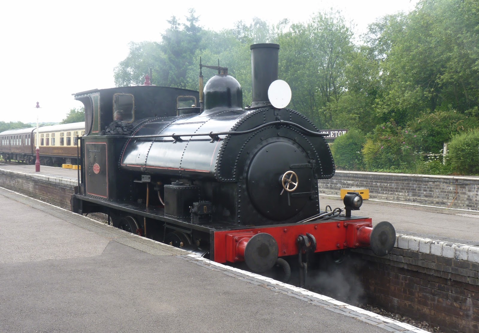
 The line here is the Churnet Valley Line, operated by the North Staffordshire Railway which was formed by Act of Parliament in 1846. The line ran from near Macclesfield to Uttoxeter, with branch lines to Stoke and Ashbourne. In common with so many other local lines, it fell foul of the Beeching Axe in the early 1960s, with the line from North Rode to Macclesfield being the first to go. By January 1965 passenger services between Leek and Uttoxeter had followed, with Leek Station finally closing in 1970. The section between Leekbrook and Kingsley is now privately operated as a tourist attraction, with the track from Kingsley to Oakamoor still laid and used for storage of locomotives and other rolling stock. The remainder of the line saw the track dismantled and the majority is now used as cycleway or footpath for leisure purposes. It therefore remains an asset to the population at large, and is indeed probably more used in its present incarnation than at any time since the invention of the internal combustion engine. It certainly provides a safe, dry and easy route alongside the river for a number of miles.
Unfortunately the first couple of miles sees the Churnet wend its way at a couple of hundred yards distance, beyond yet more grazing land but as the valley narrows it is forced into a closer proximity. Trees crowd in alongside the line, creating a shaded tunnel that is extremely pleasant on a hot day. Sarah and I have often parked at Oakamoor and cycled to the bridge at Denstone and back, relishing the cool it provides at the height of summer, although on colder autumnal days it can be dank and cloying. Woodland plants flourish in its damp micro-climate in springtime - ramsons, anemones and so on - whilst Himalayan balsam takes over into summertime. This rampant colonist, often enjoyed for its vaguely orchid-like pink flowers, is also greatly disliked for its more aggressive tendencies, choking the life from more sensitive native plants. I am also far from alone in finding their scent to be sickly sweet but, their seeds being “popped” distances of up to twelve feet and being borne by water, they are unavoidable on a walk such as this. Many wildlife trusts across the country organise “balsam-bashing” working parties, although I am unaware of any local initiatives.
We are into sandstone country now, the limestone having long been left behind and the area has long been home to a quarrying industry - the village of Hollington, in particular, being renowned as a provider of quality stone to projects such as the rebuilding of Coventry Cathedral. The magnificent ruins of Croxden Abbey, just a mile from the village and well-worth a visit, bear testament to the beauty of its colour and its resilience. The Raddle Inn within the village contains a carving of the masons’ brass square and compass in its stonework which is illustrative of the long history of stonemasonry in the village and its environs.

Growing up as a child in the 1970s, a trip to Alton Towers was a must for a every long six-week summer holiday, often with Nana and Granddad Pope in addition to Mum and Dad. In those days it was far from the licence to print money that is today’s theme park. The chief attraction in the way of rides was a cable car from the main building to the Chinese pagoda in the gardens, or a trip on the boating lake in a pedalo; there was a model railway (reputedly the world’s biggest) and sea-lions in a purpose built pool near the car-park; but above all, there were the gardens. For an eight year old boy today, the prospect of a trip to see some stately hall’s gardens would probably fill him with dread - gardens are boring, aren’t they - but the setting of a fairy glen, combined with sandstone caves, Chinese pagodas, grottoes, waterfalls, bridges, streams, stairways and statues is like manna from Heaven to the imagination. It is a garden that demands to be explored, rather than merely visited and - for the adults - there were exotic plants brought home by the best-known plant hunters of the Victorian era. “He made the desert smile” reads the dedication on the bust of the 15th Earl that gazes down upon his creation, and if not the desert, he certainly made generations of children and adults alike do so.
It is pointless to pretend that I like the development of the property into today’s tourist attraction par excellence - but, then, I am far from its target market. I like the peace, quiet and solitude of the country surrounding and have a fear of the heights that so many of the rides depend upon for their thrills. Nonetheless, I have attended firework displays and pop concerts at the venue that would not have taken place but for the other “attractions” and am happy to acknowledge that the preservation of the gardens is hugely dependent upon them also - as is a great deal of local employment. So if the price for that peace, quiet and solitude in the surrounding spectacular countryside is the gathering of tourists to this particular honey pot, I can live with that.
 Back to Pugin, though. In addition to his work in Westminster and at the Towers, he was responsible for many other local commissions. To the walker on the railway, the most obvious is the station below the village of Alton. Italianate in design, it would not look out of place in Portmerion - the William Clough Ellis designed village near Porthmadog on the Lleyn Peninsula of North Wales. Now a holiday cottage for hire, it is a beautiful building that has the one disadvantage of people like me walking past your back door throughout the day. Indeed many people, no doubt unaware of the fact that it is a private residence, clamber up onto the platform and peek through the windows expecting to see something out of the Golden Age of the Railway and instead seeing someone enjoying a lazy Sunday morning with the papers, whilst still in their dressing gown!
St Giles church, in the nearby market town of Cheadle, is reckoned to be Pugin’s masterpiece, but wonderful though it is, it lies off-route and outside of the scope of this book. Of more relevance to us is the Ramblers Retreat - a mile beyond Alton and a locally renowned tea-room and restaurant in a glorious location - and the castle, situated opposite the Towers within the village itself. The castle was originally built by a Norman family - the de Verduns - who were also responsible for the previously mentioned Croxden Abbey. They gained to right to build the castle by supporting Richard the Lionheart in his Crusades to the Holy Land. It can be seen that a religious fervour has been responsible for the creation of the majority of the notable buildings hereabouts, something that the present “castle” continues. The original castle was substantially rebuilt in the 15th century and was badly damaged during the civil war, following which it fell into a degree of disrepair. Pugin redesigned it in 1847 in his by now familiar Gothic style. It has since served time as a private house, a convent and a Catholic boarding school - until its closure in 1989. Since 1996 it has returned to its religious use, serving as a Catholic Youth Centre for the Archdiocese of Birmingham.
 One late September afternoon in the company of two good friends, Jan and Karen, I finally approached the castle from the village after many years of admiring it from the valley below and was pleasantly surprised. The village itself would be an absolute delight, were it not for the traffic passing through to and from the Towers which has always put me off in the past. But the area around the castle is an absolute gem - beautiful cottages, the wonderful St Peter’s church in its typical country churchyard, and the Catholic St John’s, yet another of Pugin’s designs. The castle itself, with its “green” copper roof is seen to best effect here, with its magnificent setting high above the valley easily appreciated. Oddly, a modern gym completes the courtyard and is, frankly, completely out of context with the medieval and Gothic that surround it. In a different setting it, too, may be a building to savour but here it is a surprising eyesore. And it may sound heretical in “Puginland” but I found the cottages and the less showy church of St Peter to be the most charming and “homely” parts of the village.
Our way into the village that afternoon had been alongside damson-filled gardens and by way of Toothill Rock, and it is that path which provides our exit today. A flat sandstone outcrop, Toothill gives awe inspiring views out over the Churnet and towards the Towers beyond. With the wind in the wrong direction, the sound of squealing can be heard from the more “thrilling” of the rides, but under normal circumstances it remains a peaceful and interesting spot. I stood here early one morning and watched a heron soar across the gorge, below eye level, and marvelled again at the grace of these beautiful birds. A squirrel clambered up a nearby tree and a robin trilled away to my left. The pressures of daily life were left behind as I sat, watched and listened. This was and remains a place to be savoured, and is possibly the view that gives rise to the Staffordshire Rhineland exaggeration, but we have a distance yet to cover and must drag ourselves away and drop steeply downhill to the riverside once more - or more specifically to the back garden of the Ramblers Retreat, a cup of coffee and one of their delicious desserts.
Once one of two gatehouses to Alton Towers itself and designed, of course, by Augustus Pugin, the Ramblers Retreat was almost derelict when purchased by Gary and Margaret Keeling in 1978. The story goes that once they had renovated the property as a family home, people would walk past and wonder whether they did tea or coffee in their attractive garden. After a while the couple gave into the inevitable and began to offer drinks and snacks from their lounge. Over the years, they extended their menu to full lunch and afternoon teas both inside and out and have developed a reputation for excellent meals that extends far and wide. The garden contains three or four summerhouses which walkers utilise in less clement weather, rather than take their muddy boots into the conservatory, and is dotted with tables that are frequented by plump little robins and sparrows keen to pick up dropped crumbs and titbits. I have taken ice-cream here on a scorching August Bank Holiday with Sarah, and coffee on a bitter cold February afternoon with Jan, when the temperature never once rose above freezing and have found it a delight on each occasion. And whilst I have yet to have a full meal here, it is an omission I am keen to remedy in the near future. And it is here that we leave Pugin Land behind us and move on to the next stage in our journey.


There are at least three ways in which we can take the route forward. A path immediately opposite the Ramblers takes you over Lords Bridge and back to the railway line and an easy way to Oakamoor a couple of miles along the valley floor. And while this remains true to the riverine nature of the path so far, there is no immediately obvious way forward without taking to a busy road out of the valley - there being no right of way alongside the river for a couple of miles and the railway becoming impassable at the blocked up Oakamoor Tunnel. A second option would be the Red Road - so named for the sandy, iron-rich soil it runs through. The road runs parallel to the railway, but on the opposite bank of the river, and was improved by Italian prisoners of war during World War II. They must have found the Italianate Ramblers Retreat a little reminder of home, and could certainly have found less attractive areas in which to while away wartime. But the Red Road option runs up against the same issue as the railway when it reaches Oakamoor, so a third alternative is required.
And to the side of the Ramblers paths wind away to Ousal Dale and The Ranger Youth Hostel or - even more enticingly - a path through Dimmingsdale (a forestry owned SSSI) to Hawksmoor (a National Trust owned nature reserve) and a pathway back to the river a few miles upstream. It is the first time in the journey that we have been far from the river for any period of time, and I initially sought to avoid the detour (leading to a little inadvertent trespassing on the Churnet Valley Railway’s land) but the path is really too good to miss and I realised that the journey would be the poorer for its omission. It is both beautiful and full of quirky historical interest and I enjoy it more on every occasion I walk it, so - although it is hard to tear yourself away from the Ramblers - let us pull on our rucksack and be off once more.
 We have gone no more than a hundred yards from the garden before we pass The Old Smelting Mill - a private residence now, with ample grounds in front, flanked by public footpaths that must prevent any degree of privacy in the front garden, although the house itself is hidden away behind high walls. Immediately beyond is a long, thin millpond, now owned by the JCB Angling Club, with a view to a gloriously situated house beyond - the house that I would buy if I won the lottery. The Smelting Mill and the pond are the first signs of the industrialisation that once occupied this valley, inconceivable though it may be today. This part of the Churnet has long been associated with iron and copper mining - we have already seen the Red Road taking its name from the ore-rich rock - and Dimmingsdale in particular owes its current appearance in no small part to the industry. We shall see and learn more of this history as we trek uphill.
These days, though, the pond is an enchanting location. I am constantly reminded of the books of Tolkien as I
walk the area - not so fanciful, as he often visited the scout camp at Kibblestone, just outside Stone a few miles away. The films are wonderful, but are not as I imagined the valley of Rivendell or Lothlorien. No walk in the valley is complete without a period sat on the low retaining wall, enjoying the antics of the ducks and wildfowl on its still waters. On that freezing February afternoon that I spoke of in the previous chapter we watched mallards flying in to land on the surface, only to skid hopelessly along the two-inch thick ice that had formed over the previous couple of days; a fortnight earlier I had been delighted by the presence of a dabchick, or little grebe, diving and dabbling in the shallow water at the side. If kingfisher and heron are the two birds that most excite me on a river walk, then dabchick and dipper are not far behind. Both are ridiculously cute and can appear comical in the way they feed from the very bottom of the water - dippers walking along the bed of fast-flowing streams and shallow rivers; dabchicks using their relatively large webbed feet to push themselves down for unfeasibly long dives in streams, rivers, canals ponds and lakes. Clearly, its ownership by an angling club illustrates that there are also fish in the depths but it is for its birdlife that I retain such affection for this pond - that and the magnificent view enjoyed by my lottery-win house as the far end.
walk the area - not so fanciful, as he often visited the scout camp at Kibblestone, just outside Stone a few miles away. The films are wonderful, but are not as I imagined the valley of Rivendell or Lothlorien. No walk in the valley is complete without a period sat on the low retaining wall, enjoying the antics of the ducks and wildfowl on its still waters. On that freezing February afternoon that I spoke of in the previous chapter we watched mallards flying in to land on the surface, only to skid hopelessly along the two-inch thick ice that had formed over the previous couple of days; a fortnight earlier I had been delighted by the presence of a dabchick, or little grebe, diving and dabbling in the shallow water at the side. If kingfisher and heron are the two birds that most excite me on a river walk, then dabchick and dipper are not far behind. Both are ridiculously cute and can appear comical in the way they feed from the very bottom of the water - dippers walking along the bed of fast-flowing streams and shallow rivers; dabchicks using their relatively large webbed feet to push themselves down for unfeasibly long dives in streams, rivers, canals ponds and lakes. Clearly, its ownership by an angling club illustrates that there are also fish in the depths but it is for its birdlife that I retain such affection for this pond - that and the magnificent view enjoyed by my lottery-win house as the far end.

One of the many beech trees on the left bank has a poppy wreath pinned or stapled to it - one that I understand is regularly replaced and cared for. Below it is nailed a laminated notice, reading as follows :
“Dedicated to RSM Tom Beardmore.
Born and bred in Cheadle and killed in Italy 3/2/44, aged 27, whilst clearing the “Gustav” German defensive line 10 miles south of Monte Cassino. He loved this place but sadly, like many more brave men, did not return home.
No known grave.”

red and unaffected by the winter weather and the notice was attracting a great deal of attention. It is touching to think that 64 years after his death, RSM Beardmore is still remembered - maybe by the next generation, maybe the one after, but I can’t help feeling that he stands for all of those other brave men in addition to himself who did not return home. There are other memorials along the path - many, many benches dedicated to people who loved the valley - but it is this simple laminated notice explaining the presence of the wreath that most truly affected me. It does appear, though, that this valley inspires love in a great many people - there are no other stretches of the walk that seem to inspire such devotion in its visitors.
To either side of the stream, rocky sandstone outcrops with names such as Earl’s Rock, Painter’s Rock and Wright’s Rock peep through the undergrowth and lend a still more Tolkienesque feeling - one that is temporarily destroyed by the noise of laughing children as they fly above the stream on one of the many rope swings dotted along the way. Taking the opportunity to cross to the less-frequented right bank you notice a subtle change in the treescape - less beeches, more birch - and also in the vegetation. No doubt this is partly to do with the relative amount of sunlight received, and the differing quality of the soil, but is also down to the way in which the woodland was managed in the past. The right bank has been extensively coppiced in the past - cut down to trunk level every ten or twelve years to encourage regenerative growth in a number of smaller shoots - in order to provide fuel for the smelt mill or for the furnace higher up the valley. There are also a number of older oaks, primarily down in the damp ground next to the stream.
I couldn’t help but notice the number of trunks - especially the beeches - that had been disfigured by the carving of names and initials into them. It is difficult to see a difference between this rural habit and the wanton vandalism that is the painting of graffiti on urban walls. The only thing I can find to be said in its favour is that the scars will eventually heal over and the inscriptions disappear in the fullness of time. Another sign of the age of trees - and of the damp environment - is the fungi that appears on so many of the trunks, along with the abundant moss. There are so many different varieties that you can never be bored, which makes for a very slow pace to the walk as there is always something of interest to be looking at.
 One bitter cold winter‘s afternoon, walking downhill though a Dimmingsdale dusted with a light covering of frost, I spotted a lesser spotted woodpecker here - the first time I’d seen one. There’s a pleasure in seeing a new bird for the first time, even though I don’t count myself as a birdwatcher particularly, and it was good to be able to point it out to Jan, who enjoys Dimmingsdale (and certainly The Ramblers) as much as I do. She’d spotted it at the same time as I had, but hadn’t dared to believe it was woodpecker, as it was her first woodpecker of any variety. We watched it for a few minutes as it flitted between tree-trunk and branches before it tired of entertaining us and disappeared. We also made our excuses and left - in our case heading for a fruit crumble and custard; the bird for a less fattening meal of beetle grubs and insect larvae. I know which menu I preferred.
The retaining wall to the next dam is clearly covered in algae - I have seen mallards dangling over the edge to dabble at its face and wondered at their willingness to put themselves in such an uncomfortable situation for what seem such meagre pickings. That algae must be delicious. But if you’re going to eat out in this way, you may as well find such a lovely spot in which to do so. The pond immediately above the dam is one of the biggest and is lined on one side by rhododendron bushes, which must be a delight when reflected in the water in late spring. Behind the bushes are a couple of dead trees, and while no-one wants to see plants die, there can be a gnarled quality, a starkness and an elegance about their trunks and branches that I find exceptionally photogenic. Sarah tells me that I take too many photos of single trees but I find them endlessly fascinating. I may not be able to identify trees with any degree of confidence or accuracy but I do love the shapes they create - dead or alive - and find joy in their company. Part of me feels that it is a pity we have avoided woodland for so long during the walk but we are certainly amply rewarded now.
On one of the trunks I noticed a blue disc bearing the legend “Sabrina Way Long Distance Route” and, while I was doing the walk and writing this book for my own pleasure more than anything, I was appalled to think that someone had got there before me - not quite Scott seeing the Norwegian flag above the South Pole and realising that Amundsen had beaten him to it, but a disappointment none the less - and was delighted to see on the internet that evening that it was primarily a route for horse riders, linking Hartington with a place called Great Barrington near Bourton on the Water in The Cotswolds over 200 miles away. Why these two are the start and finish, I’m unsure, but am glad that the route I am devising remains (at the very least) unofficial to date.
Moving higher up the valley the ground underfoot gets muddier, although it’s perhaps more leaf mould than mud. To the left, the ponds seem shallower and appear more natural now, reed-fringed and with a more “wild” feeling. They are linked by a stream that winds sinuously across its mini-floodplain and reminds me of Sher Brook on Cannock Chase where I spent a lot of time as a child. On the other side of the brook is a sign that reads Alton Abbey 2 miles - the Abbey turned into Alton Towers and it is a surprise as to how close we still are - the walk from the village seems to have taken an inordinately long time for two miles but is reflective of the sustained interest it has provided.
The valley changes subtly above the milestone, becoming more open, less tree-lined and the artificial nature of

the landscape becomes briefly more apparent in the channel that the stream runs through to the side of the pathway. I use the word artificial not in any sense of criticism, for I have enjoyed the last few miles as much as any since Dovedale, and understand that each of the landscapes we have passed through are - in their own way - artificial, having been influenced by agriculture, by conservation, by the National Trust, by the desire to create an angling paradise or a power source for mills. It is true, though, that this valley was created as though it were a garden and so can be regarded as “more” artificial perhaps than the others.

the landscape becomes briefly more apparent in the channel that the stream runs through to the side of the pathway. I use the word artificial not in any sense of criticism, for I have enjoyed the last few miles as much as any since Dovedale, and understand that each of the landscapes we have passed through are - in their own way - artificial, having been influenced by agriculture, by conservation, by the National Trust, by the desire to create an angling paradise or a power source for mills. It is true, though, that this valley was created as though it were a garden and so can be regarded as “more” artificial perhaps than the others.
As it narrows into a more pronounced V-shape and passes below yet another pond - from which emerges the stream by way of a wonderful little waterfall - we emerge onto a metalled road once more. It’s a single track road, with grass growing down the middle, that serves only the tiny hamlet and assorted houses dotted along its sides as it wends its way down Stony Dale to Oakamoor - but it’s a road nonetheless and would lose some of its charm were it any less interesting than that which has gone before. Happily, I have only ever met two vehicles at this end and consider it an honorary footpath - despite its designation on a map.
 The hamlet is known as Old Furnace and clearly takes its name from the location of an iron making furnace here at some stage in the dim and distant past. No traces remain now to be seen, but a Channel Four “Time Team” investigation a few years ago indicated that it was located beneath the row of cottages at the heart of the community. They also discovered some pottery that suggested a site here as early as the 10th or 11th century. The valley has always been a preferred site for industry, it seems, although it is now a rural idyll and without question my favourite settlement of the entire expedition. There is no pub, no shop, no post office, no church, no school - none of the facilities that you would look for in a village, you’d think, but it has peace, it has quiet, it has birdsong, it has history, it has charm, it has character. It is special. Please enjoy it and then follow the road uphill and away, leaving it just the way you found it. There are pleasures still to come - trust me.
The Silver Stream, which has accompanied us throughout our time in Dimmingsdale, issues from the last lake in the valley, situated on private ground beyond a renovated farmhouse named (imaginatively) Lake View. The road takes a turn to the right here and clambers away uphill. The depth of the road in comparison with the fields to either side suggests an ancient sunken lane - worn down by the amount of traffic it has received over the years - again indicative of the age and former importance of the hamlet. Hedges line the road to either side and with the height of the banks anyway, the views are minimal but there remains interest.
About a quarter of a mile uphill there lies a row of terraced cottages to the right, at ninety degrees to the road. A plaque on the end wall advises that Greendale Cottages were “homes of brass and copper workers, given to the National Trust in 1987 by Mrs M C Aldridge who loved Hawksmoor and the surrounding countryside.” This is the first mention of Hawksmoor, the nature reserve that lies over the main Cheadle-Oakamoor road at the top of the hill but I am intrigued by the name “Greendale” when we have seen just how influenced by industry the area has been.
A few yards further, to the left this time, is Greendale Farm. It seems an entirely unremarkable farmhouse - and indeed it is - but take a look back as you pass and you will see the door and its surrounds have been painted with scenes of mountain and woodland in a very similar fashion to the way in which narrow boats are decorated with pictures of castles and flowers. I can’t remember seeing a house decorated in this fashion before and although I don’t like the plaster eagle to one side of the door, or some of the other birds and animals dotted around the yard, I do like the pictures and the individuality that the pictures demonstrate. There is some thought and creativity that has gone into the idea, and they’re fun. It would look completely out of place on our door on an estate in a village on the edge of the Potteries, and would be ridiculous in some other locations but here in Greendale it works.
Up the hill and around the corner the Cheadle-Oakamoor road is reached and crossed, our way passing between two imposing gates immediately opposite the lane. But before walking through the gates and into the tiny car park beyond, take a few moments to read the plaque:
“These gates were erected to honour the memory of John Richard Beech Masefield, the founder of the Hawksmoor Nature Reserve. He was a great naturalist with an unrivalled knowledge of the fauna and flora of his native county. For forty-nine years he was a member, and four times president , of the North Staffs Field Club and was ever ready to help and encourage others in the study of Natural History.
1933”
The gates were officially inaugurated by another John Masefield, the cousin of the man to whom they are dedicated and - incidentally - Poet Laureate from 1930 to his death in 1967. The poet was responsible for such poems as Sea Fever (“I must go down to the sea again/To the sea and the ships and the sky”) and did indeed sail with the merchant navy in his younger days, mentioning his delight in flying fishes, porpoises and birds in his daily journal but it is JRB Masefield in whom I am most interested right now. (Fret not, though, we shall be meeting another Poet Laureate within a few short miles.)
JRB Masefield was born in 1850 in Cheadle and appears to have devoted his life to the study of nature. His family as a whole appears to have had a literary bent - in addition to the cousin a Charles John Beech Masefield, who I assume to be his brother, was a minor war poet and novelist who died of wounds received in France in 1915. “Our” Masefield seems to have combined this writing ability with his love of nature to enthuse others in the world about him. He appears to have loved all sorts of wildlife, from mammals to birds (there is a letter in the county records about the shooting of a white-tailed sea eagle at Shugborough Hall) to reptiles to insects, but what I find perhaps the most remarkable thing about him is the collection of land and freshwater snails from between 1883 and 1921 that is now held at the Potteries Museum - all 2084 of them. Let me just repeat that - 2084 land and freshwater snails collected over a 38 year period. I’m older than 38 (not by much) and would be flabbergasted if I’d seen that many snails, never mind actually collected them. (Unbelievably, two collectors have subsequently exceeded that total, but without the other strings to their bow that Masefield had - the first county record of a sand lizard, spotted on Cannock Chase in 1886 for example). Truly, his knowledge of the flora and fauna must have been unsurpassed. Surely a man as deserving of his memorial gates as would be his more famous cousin.

On the far side of the river runs the Churnet Valley Railway - albeit not for passenger services here, only for the storage of old rolling stock during or prior to its renovation. As previously hinted, I have once inadvertently trespassed on the track here having misread the map and although it’s immeasurably drier underfoot than the glutinous mud of the footpath, it is far from easy walking, the bed of the track being stony and the sleepers wet and slippery. The wide open nature of the valley gives some feeling of the film “Stand By Me” in which four young boys in middle-America set out to find a rumoured dead body and use the rail track to find their way. It sounds a slightly morbid plot summary (and does come from a Stephen King short-story) but is instead warmly nostalgic and full of the joy of childhood friendships, long summer holidays and storytelling. There is one scene in particular that I love - the one in which the young narrator wakes early and wanders away from the basic little camp to the line itself where he finds himself yards from a young deer fawn. They stare at each other for a long few seconds, before the fawn turns away and strolls back into the trees and the boy returns to his friends, never saying a thing about those few precious moments he has shared with nature. I’m afraid I would have talked of it incessantly had I been the young boy - but it’s a special moment and to keep it secret was to keep it special. A lovely film and I was happy to be reminded of it - although I hoped not to find a dead body anywhere along the way.
We are back in open fields here, not dissimilar to the Ashbourne-Rocester stretch and my day was again
blessed with the presence of buzzards, as it had been on the earlier section. My attention was caught by the sound of mewing from the sky above and I raised my eyes to see not one or two, but six gloriously soaring birds. Their “mewing” is a touch incongruous - a curiously unthreatening noise from these masters of the skies - but it is the way the cries are described in all of the books I have read. There were obviously some good thermals coming from the woods opposite and I sat on one of the stiles linking two fields and observed their circling for a quarter of an hour or so, before watching them come out of formation and sail over my head to land on a tree in the woods behind. There is a Van Morrison line that summed up the moments perfectly - “We stood enraptured by the silence/As the birds sang their heavenly song” - as I turned my eyes from the buzzards’ landing back to the way ahead, just in time to spot a curlew, its down turned beak perfectly in profile as it crossed the valley in the opposite direction no more than fifteen or twenty yards in front of me. There was, to be honest, little in the way of “heavenly song” but the silence and the rapture were certainly present. Moments like this are what we walk for, are they not?
blessed with the presence of buzzards, as it had been on the earlier section. My attention was caught by the sound of mewing from the sky above and I raised my eyes to see not one or two, but six gloriously soaring birds. Their “mewing” is a touch incongruous - a curiously unthreatening noise from these masters of the skies - but it is the way the cries are described in all of the books I have read. There were obviously some good thermals coming from the woods opposite and I sat on one of the stiles linking two fields and observed their circling for a quarter of an hour or so, before watching them come out of formation and sail over my head to land on a tree in the woods behind. There is a Van Morrison line that summed up the moments perfectly - “We stood enraptured by the silence/As the birds sang their heavenly song” - as I turned my eyes from the buzzards’ landing back to the way ahead, just in time to spot a curlew, its down turned beak perfectly in profile as it crossed the valley in the opposite direction no more than fifteen or twenty yards in front of me. There was, to be honest, little in the way of “heavenly song” but the silence and the rapture were certainly present. Moments like this are what we walk for, are they not?
 I was brought back to earth with a jolt, though, by the sound of gunshots ahead of me. Someone was either out looking for something for the pot for lunch or - and I hope that this is not the case - trying to control the bird population. Birds of prey have been having a surge in population again after the persecution of the 50s, 60s and 70s when they were routinely poisoned and also suffered from the effects of DDT thinning their eggshells, leading to the near-extinction of many species. Happily this trend has been reversed, but not to universal approval, and the occasional prosecution for poisoning can only serve to highlight this. As I heard no more shots, I put it down to someone who’d got their rabbit stew sorted and put it to the back of my mind.
The next half-mile or so is perhaps the muddiest of the whole route, being immediately alongside the water on fields that are an obvious floodplain and maintain a high water-table. The fact that the pathway is constricted in places by gorse, barbed wire and fencing means that everyone who passes this way puts their feet in the same places and only adds to the mire. There will be no clean boots by the time we reach Froghall. If this gives the impression that the path is neglected I can only apologise, for the way lies across a wooden footbridge of obviously recent vintage - it has yet to acquire that patina of age that mosses and lichens provide. The few yards beyond, as the path crosses the railway line and works its way uphill, are still muddier than what has gone before and there is no alternative but to keep moving in the hope that you sink no deeper than the top of your boots - if you pause for just a second, you will most assuredly do so!
A quarter of mile of walking parallel to but slightly above the track and a gate gives way to a crossing over the tracks and ever-improving conditions underfoot. It’s not the prettiest of entrances to a village we shall see - there’s a sewage farm, a car graveyard and body shop to admire before the back of The Railway Inn gives way to the main Cheadle-Ashbourne road. A right turn, and the station itself is reached no more than twenty yards downhill. This is Kingsley and Froghall station, the southern terminus of the modern Churnet Valley Railway - our paths coincide for the few miles to Cheddleton so I shall not dwell on its history for now. Only to say that the station, reopened in 2003 by Pete Waterman (writer/producer of I Should Be So Lucky and numerous other hits for Kylie, Jason Donovan, Rick Astley and others as part of the Stock-Aitken-Waterman “Hit Factory” in the late 80s) is beautifully restored, with posters advertising day trips to Burslem and other tourist attractions and is the possessor of another fine tea-shop. It’s not the Ramblers Retreat, but enjoy a slice of cake here. You’ll have earned it and as it helps to support the railway you can feel you’re doing your bit for a charity at the same time.